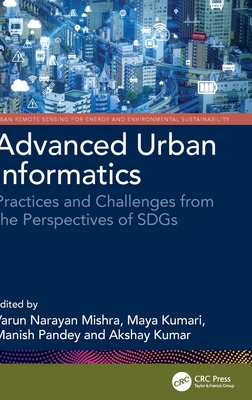
Advanced Urban Informatics: Practices and Challenges from the Perspectives of SDGs
暫譯: 進階城市資訊學:從SDGs的角度探討實踐與挑戰
Mishra, Varun Narayan, Kumari, Maya, Pandey, Manish
- 出版商: CRC
- 出版日期: 2026-09-10
- 售價: $7,610
- 貴賓價: 9.5 折 $7,229
- 語言: 英文
- 頁數: 444
- 裝訂: Hardcover - also called cloth, retail trade, or trade
- ISBN: 1032955066
- ISBN-13: 9781032955063
-
相關分類:
地理資訊系統 Gis
海外代購書籍(需單獨結帳)
相關主題

商品描述
Urban informatics is an interdisciplinary approach to understanding, managing, and designing cities using methods based on advanced geospatial methods, computer-based information technologies and other emerging tools. This book provides understanding of developments in geospatial and computational techniques, focusing on the growth/pattern of cities and its implications for the development of smart and sustainable cities from the perspectives of Sustainable Development Goals (SDGs). It covers sustainable development, land use patterns, urban growth analysis, environmental impacts, infrastructure management, and policy. The book focuses on interdisciplinary approach using geospatial data, geographic information systems (GIS), and advanced computational methods to address the challenges in urban informatics.
- Addresses the problems in implementing smart city initiatives, designing more adaptive, responsive, and resilient cities
- Offers insightful dimensions to better understand the spatial urban pattern and future projection of for suitable planning and management
- Discusses theoretical and applied research practices along with background information on the use of advanced technologies in the domain of urban studies
- Includes practical examples, case studies, and methodologies
This book is aimed at graduate students and researchers in environmental engineering and remote sensing.
商品描述(中文翻譯)
城市資訊學是一種跨學科的方法,旨在利用基於先進地理空間方法、計算機資訊技術及其他新興工具來理解、管理和設計城市。本書提供了對地理空間和計算技術發展的理解,重點關注城市的增長/模式及其對智慧和可持續城市發展的影響,並從可持續發展目標(Sustainable Development Goals, SDGs)的角度進行探討。內容涵蓋可持續發展、土地使用模式、城市增長分析、環境影響、基礎設施管理和政策。本書專注於使用地理空間數據、地理資訊系統(GIS)和先進計算方法的跨學科方法,以應對城市資訊學中的挑戰。
- 解決實施智慧城市倡議中的問題,設計更具適應性、響應性和韌性的城市
- 提供深入的維度,以更好地理解空間城市模式及未來規劃和管理的適宜性預測
- 討論理論和應用研究實踐,並提供有關在城市研究領域使用先進技術的背景資訊
- 包含實用範例、案例研究和方法論
本書旨在為環境工程和遙感領域的研究生和研究人員提供參考。
作者簡介
Dr. Varun Narayan Mishra is currently working as an Assistant Professor at Amity University, Noida, India. He completed doctorate from Indian Institute of Technology (BHU), Varanasi and M.Tech. in Remote Sensing from Birla Institute of Technology, Mesra, Ranchi, after completing M.Sc. degree in Physics. He is an experienced researcher with a demonstrated history of teaching in the field of remote sensing & GIS, spatial data analysis and modelling, digital image processing, AI & ML. His main research interests are Radar remote sensing, SAR interferometry, land change simulation & modelling, landslides and flood susceptibility modelling, vulnerability, and risk assessment. He has published several research papers in various reputed international peer reviewed journals. He also authored many edited books, reference books and book chapters with reputed publishers.
Dr. Maya Kumari is currently working as Assistant Professor at Amity University Uttar Pradesh. She has done her Doctoral degree from Guru Gobind Singh Indraprastha University, New Delhi, and M.Tech. in Remote Sensing technology from Birla Institute of Technology, Mesra, Ranchi. She also has done master's degree in environmental science from Banaras Hindu University, Varanasi, India. She has 13 years of teaching and research experience in GIS and Remote Sensing. Her specialization is the theory and practice of global positioning and navigation system, digital image processing, application of Remote Sensing in Environment & natural resource management and spatial data modeling. She has published several research papers in national and international conferences/journals related to the field of Remote Sensing and GIS.
Dr. Manish Pandey is a research assistant professor at the University Center for Research & Development (UCRD) at Chandigarh University, India. His expertise lies in the fields of geomorphology and the application of artificial intelligence, remote sensing & Geographic Information Systems in various domains of physical geography. He completed his undergraduate and post-graduate studies in Geography at the University of Allahabad, Uttar Pradesh. During his academic journey, Dr. Pandey received prestigious research grants as a Junior and Senior Research Fellow (JRF/SRF) from the Council of Scientific and Industrial Research (CSIR), which supported his doctoral research in fluvial geomorphology. Dr. Manish Pandey's research focus revolves around harnessing artificial intelligence, machine learning, and deep learning algorithms to model the behavior of earth surface processes, such as flooding, landslides, groundwater potential, and landscape evolution. He has published several peer-reviewed articles in high-impact journals, book chapters, and 2 edited books.
Dr. Akshay Kumar works as a Research Associate at the Environmental Science and Engineering Department, Indian Institute of Technology (IIT), Bombay. He graduated with an M.Sc in Geology from Ranchi University, Ranchi. He did his M.Tech. and Ph.D in Remote Sensing from Birla Institute of Technology, Mesra Ranchi. Before joining IIT Bombay in 2021, he worked as a Research Associate (Remote Sensing and GIS) for MPKV, Rahuri, supporting the climate-smart agriculture project. He has produced high-quality knowledge research reports and publications for addressing complex environmental issues to diverse audiences. He has more than ten publications in reputed national and international peer-reviewed journals, besides having six book chapters to his credit. His research interests include various hazards associated with coal mining activities, such as air pollution exposure modelling, land degradation, coal fire, topographic change, vulnerability and risk assessment, Spatial Analysis and Modelling, water quality assessment, groundwater potential, and pollution modelling.
作者簡介(中文翻譯)
Dr. Varun Narayan Mishra 目前在印度諾伊達的阿米提大學擔任助理教授。他在印度理工學院(BHU)瓦拉納西獲得博士學位,並在比爾拉科技學院(Birla Institute of Technology)梅斯拉(Mesra)獲得遙感技術的碩士學位,之前完成了物理學的碩士學位。他是一位經驗豐富的研究者,擁有在遙感與地理資訊系統(GIS)、空間數據分析與建模、數位影像處理、人工智慧(AI)與機器學習(ML)領域的教學歷史。他的主要研究興趣包括雷達遙感、合成孔徑雷達(SAR)干涉測量、土地變化模擬與建模、滑坡與洪水易感性建模、脆弱性及風險評估。他在多個知名的國際同行評審期刊上發表了多篇研究論文,並與知名出版社共同編著了多本編輯書籍、參考書籍及書章。
Dr. Maya Kumari 目前在阿米提大學(Uttar Pradesh)擔任助理教授。她在新德里的古魯戈賓德辛格印德拉普拉斯塔大學獲得博士學位,並在比爾拉科技學院(Birla Institute of Technology)梅斯拉獲得遙感技術的碩士學位。她還在印度瓦拉納西的班納拉斯印度大學獲得環境科學的碩士學位。她在地理資訊系統(GIS)和遙感領域擁有13年的教學和研究經驗。她的專長是全球定位與導航系統的理論與實踐、數位影像處理、遙感在環境與自然資源管理中的應用以及空間數據建模。她在與遙感和GIS相關的國內外會議/期刊上發表了多篇研究論文。
Dr. Manish Pandey 是印度昌迪加爾大學(Chandigarh University)研究與發展中心(UCRD)的研究助理教授。他的專業領域包括地貌學以及人工智慧、遙感和地理資訊系統在物理地理各個領域的應用。他在印度烏塔爾普拉德什的阿拉哈巴德大學完成了地理學的本科和研究生學習。在學術旅程中,Dr. Pandey 獲得了科學與工業研究委員會(CSIR)頒發的榮譽研究獎學金,支持他在河流地貌學的博士研究。Dr. Manish Pandey 的研究重點是利用人工智慧、機器學習和深度學習算法來建模地表過程的行為,例如洪水、滑坡、地下水潛力和景觀演變。他在高影響力的期刊上發表了多篇同行評審文章、書章以及兩本編輯書籍。
Dr. Akshay Kumar 在印度理工學院(IIT)孟買的環境科學與工程系擔任研究助理。他在蘭契大學獲得地質學的碩士學位,並在比爾拉科技學院(Birla Institute of Technology)梅斯拉獲得遙感的碩士和博士學位。在2021年加入IIT孟買之前,他曾在MPKV(Rahuri)擔任研究助理(遙感和GIS),支持氣候智慧型農業項目。他為解決複雜的環境問題製作了高品質的知識研究報告和出版物,面向多樣的受眾。他在知名的國內外同行評審期刊上發表了十多篇論文,並擁有六個書章。他的研究興趣包括與煤礦活動相關的各種危害,例如空氣污染暴露建模、土地退化、煤火、地形變化、脆弱性和風險評估、空間分析與建模、水質評估、地下水潛力和污染建模。